
When you are buying a home, there are many things to take into consideration. One of the most important is the history of the property. By using Google Earth, you can research old maps of the house to get a better idea of what it used to look like. Then you can use the taken images by clearing with AI image upscale tools. This information can help you in assessing potential repairs that may need to be done, or in negotiating with the seller.
Get Clearer House Maps with VanceAI Image Upscaler
Old Google Earth maps and historical aerial imagery are often saved at lower resolutions than today's satellite views. To inspect property boundaries, garden layouts, or old building footprints clearly, you'll usually need to enlarge the image — but standard zoom degrades quality fast. The VanceAI Image Upscaler solves this by upscaling captured map images while preserving lines, labels, and texture detail.
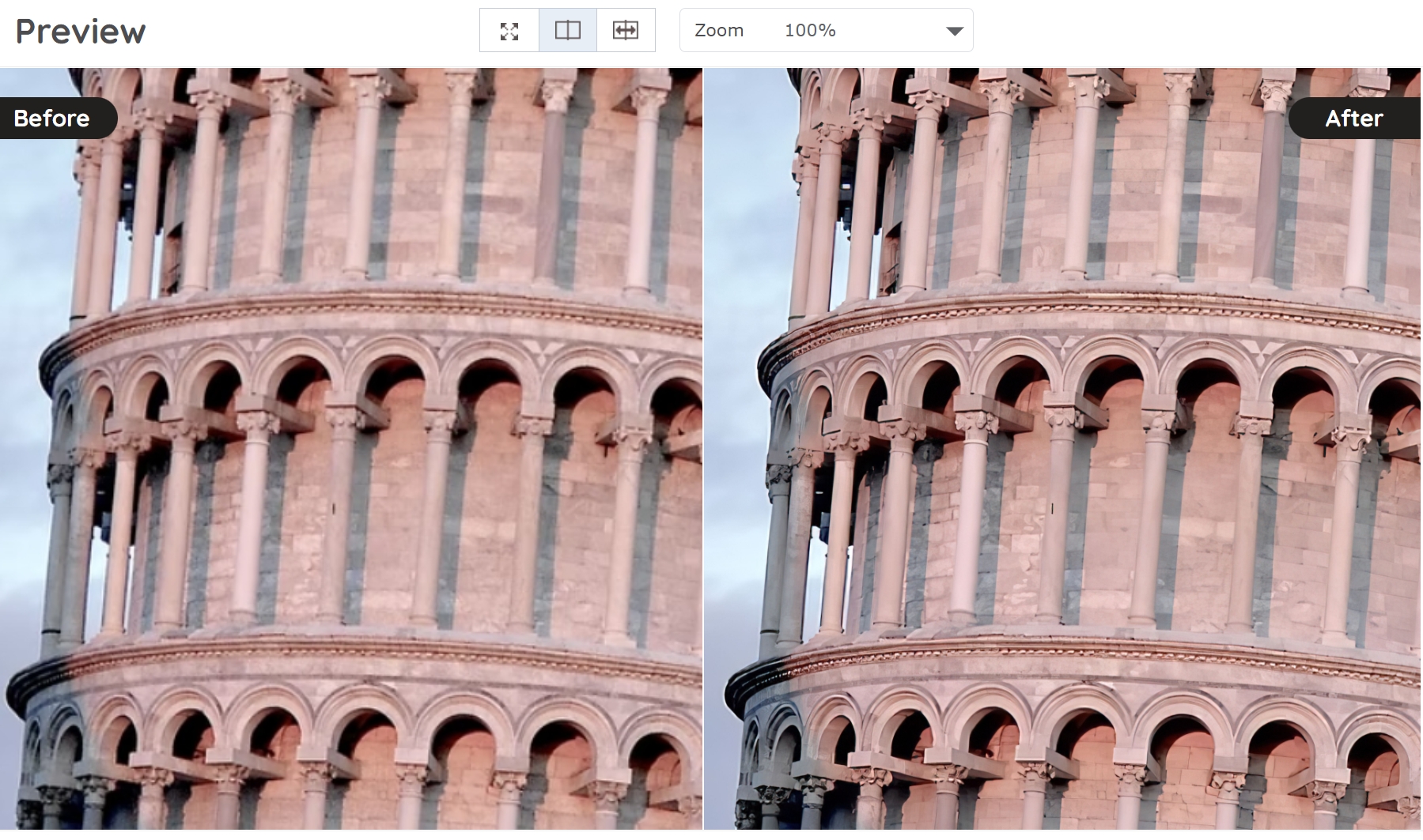
Run the workflow as a pair: capture the historical image from Google Earth, then upscale it 2x or 4x in VanceAI for a clearer view of the property history. The result is a map you can actually read — outlines of demolished outbuildings, the boundary of a former orchard, or the position of a since-removed driveway. For very low-resolution captures, run a Denoise pass before upscaling for the cleanest output.
What Is Google Earth?
Google Earth is a free program that gives you satellite imagery and 3D map views of nearly any point on the planet. The historical imagery feature lets you scrub through past satellite captures to see how a location has changed over years or decades.
For house and property research, Google Earth is a strong starting point. Old aerial captures show driveway changes, outbuilding additions or demolitions, garden layout shifts, and even significant land use changes (a former orchard now suburban subdivision, a removed silo, a re-routed driveway). The information is useful when buying a home, assessing potential repair work, or negotiating a property purchase.
Method One: Find Old House Maps in the Google Earth Web Browser
Google Earth runs in any modern browser (Chrome, Firefox, Safari, Edge). The browser version is the fastest way to access historical imagery without installing software.
Step 1: Enter the Property Address
Open earth.google.com and type the property's address into the search bar. A satellite view of the property loads automatically.
Step 2: Open Historical Imagery
Look for the "Historical Imagery" or "Timelapse" option in the left-hand menu. Clicking it brings up a timeline at the bottom of the screen showing each year's available satellite capture.
Step 3: Scrub Through the Years
Click any year in the timeline to load that year's satellite image. Older captures are typically from 1985 onward in the US and from the early 2000s in most other countries. You can switch between years to compare how the property changed over time.
Step 4: Save the Image
To save a snapshot, use your browser's screenshot tool (Cmd/Ctrl + Shift + S on most browsers) or right-click and save the image. The captured snapshot can then be uploaded to VanceAI Image Upscaler for a sharper enlargement.
Method Two: Find Old House Maps in Google Earth Pro Desktop
Google Earth Pro is the free desktop application with deeper historical imagery and 3D viewing tools than the browser version. Download it from the official Google Earth Pro page.
Step 1: Download and Install Google Earth Pro
Visit the Google Earth Pro download page and install the application for Windows, Mac, or Linux. Installation takes a few minutes.
Step 2: Enter the Property Address
Open Google Earth Pro and type the property address into the search bar. A yellow pin marks the location on the satellite map.
Step 3: Open Historical Imagery
Click the clock icon ("Historical Imagery") in the top toolbar. A timeline appears at the top of the screen showing every available historical capture.
Step 4: Scrub Through the Timeline
Drag the timeline slider to any year to view the satellite image from that date. Earlier captures are typically lower-resolution than modern imagery — this is where the VanceAI upscale step makes a real difference.
Step 5: Switch to 3D View
Click the 3D View button to see the property in three dimensions for the selected date. This is especially useful for understanding building height, roofline changes, and neighboring structures over time.
Step 6: Save the Map
Use File → Save → Save Image to export the current view as a PNG. The exported image can then be upscaled in VanceAI for a sharper, more readable version.
Other Historical Map Sources Worth Checking
Google Earth isn't the only source for old house maps. For deeper historical research, also check:
- Sanborn Fire Insurance Maps — Highly detailed 19th and early-20th-century property maps used by insurance assessors. Available through the Library of Congress and state libraries.
- USGS Historical Topographic Map Collection — US Geological Survey historical maps showing land features and property layouts going back to the late 1800s.
- Old Maps Online (oldmapsonline.org) — Aggregates historical maps from libraries and archives worldwide.
- Local Historical Society — Many towns and counties hold detailed property maps in their archives, often including individual lot survey drawings.
Pair these sources with Google Earth's aerial captures for a complete property history.
Frequently Asked Questions
How far back does Google Earth's historical imagery go?
Most US locations have satellite imagery back to 1985, with annual captures from the early 2000s onward. Older captures are aerial photographs digitized from archive sources. Coverage outside the US varies — Europe has good coverage from the early 2000s, while less developed regions may only have imagery from the past decade.
Is Google Earth Pro free?
Yes. Google Earth Pro is fully free as of 2026 — it used to be a paid product but Google made it free in 2015. Download it from the official Google Earth Pro page.
Can I see street-level views of old houses in Google Earth?
Google Earth shows satellite imagery only — for street-level historical views, switch to Google Street View. Street View also has a historical mode (the clock icon in the corner) that lets you scrub through past street-level captures.
How do I find pre-1985 aerial imagery of a property?
Google Earth's coverage gets thin before 1985. For earlier aerial imagery, check the USGS Earth Explorer, your state's historical society, or the National Archives aerial photography collection. These sources often have flight imagery going back to the 1930s and 1940s.
Can I get a high-resolution print of a Google Earth image?
The default Google Earth save creates a screen-resolution image. For printing, use VanceAI Image Upscaler to enlarge the captured image 2x or 4x while preserving detail. For very small captures, stack a denoise pass before upscaling.
Why does the old satellite image look blurry?
Older satellite captures used lower-resolution sensors and were stored at smaller file sizes than modern imagery. The blur is real loss, not a display artifact. AI upscaling can recover plausible detail, but cannot perfectly recreate what wasn't captured originally.
Can I trace property boundaries from old Google Earth maps?
Yes, but with caveats. Aerial photography shows visible features — fences, hedges, driveway lines — but not legal property boundaries. For official boundary research, check your county's GIS portal and historical property deeds. Combine the legal records with aerial photography for the complete picture.
How accurate are old Google Earth captures for legal purposes?
For informal research (assessing repair history, understanding property changes), they're highly useful. For legal disputes or formal property surveys, always pair Google Earth with official county records. Most courts accept Google Earth imagery as supporting evidence but not as authoritative boundary documentation.
Can I overlay old maps on current Google Earth views?
Yes, in Google Earth Pro. Use File → Import to load a georeferenced historical map as an overlay, then adjust transparency to compare directly with current satellite imagery. This works best with Sanborn maps and USGS topographic maps that already have geographic coordinates.
How do I share an old Google Earth view with someone else?
Use the Share or Copy Link option to create a URL pointing to the same location and zoom level. For historical imagery, the URL doesn't include the year — you'll need to send the year information separately or save and share the image directly.
Conclusion
Google Earth is a strong starting point for finding old house maps, especially when you pair it with VanceAI Image Upscaler for a sharper view of low-resolution captures. For deeper historical research, supplement with Sanborn fire insurance maps, USGS topographic collections, and your local historical society. Together, these sources give you a clear picture of a property's history — useful for assessing repairs, negotiating a purchase, or simply understanding the land you're standing on.